Welcome to the Keweenaw Geoheritage Geoatlas!
GeoAtlas Basics
The GeoAtlas is an interactive webmap that allows users to explore a curated list of geographic, cultural, and industrial heritage data layers for Keweenaw, Houghton, and Baraga Counties. Below you will find some basic instructions for navigating the GeoAtlas. Navigation
NavigationTo navigate the GeoAtlas, click and drag the map with the mouse cursor.
Zoom-in or Zoom-out with the mouse scroll wheel OR use the
 and
and  , located in the upper left-hand corner of the GeoAtlas.
Click on one features of interest on the GeoAtlas to learn more information.
The Layer List
 contains all layers, organized into collapsible data categories, that can be expanded to view all of the layers under a designated category.
Click on
 to expand and view the contents listed under a data category.
Click on
 to collapse the data category contents.
The Layer List
also allows you to toggle layers on and off by clicking on the visibility icon.  Indicates that the layer IS visible on the map.
  Indicates that layer IS NOT visible on the map.
 Be aware, some layers are only visible at certain zoom-levels. Layers not visible at your current zoom-level will appear grayed-out in the Layer List.
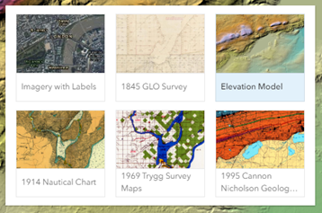
The Base Map Gallery is located in the lower left corner of the GeoAtlas and it allows you to change the underlying map which all other layers are drawn upon.
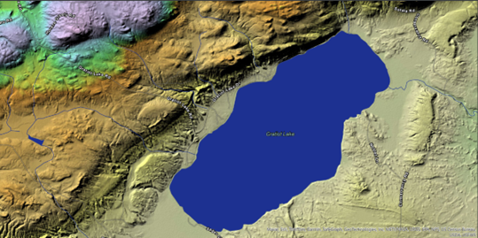
The default base map is the Imagery without Labels.
To change the base map, click on one of the other options in the Base Map Gallery.
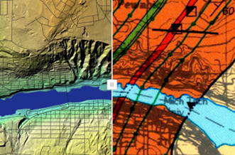
The Swipe Tool
 enables you to easily compare the content of different layers in the GeoAtlas with a base map of choice using a sliding vertical swipe bar.
To start, select a base map of interest from the Base Map Gallery and turn on the visibility for each layer of interest in the Layer List.
Next, click on the Swipe Tool
to activate the sliding vertical swipe bar.Click and drag the sliding vertical swipe bar handle
 across the map to compare the selected layers to the selected base map.
To deactivate the sliding vertical swipe bar, click on the Swipe Tool.
The Print Tool
 allows you export the current view of the GeoAtlas to a variety of printable formats.
Printable Formats: PDF (georeferenced), PNG32, PNG8 JPG, GIF, EPS, SVG, SVGZ, AIX, TIFF.
To Export the current display of the GeoAtlas, click on the Print Tool
to activate the Export window. Select one of two export options: Layout or Map Only. Exporting layout includes information such as title, author, date, scale bar, credits, legend and a north arrows. Map only exports only the current map display without additional information.
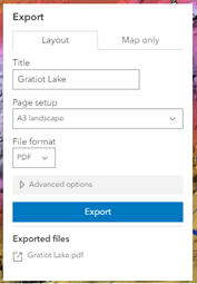
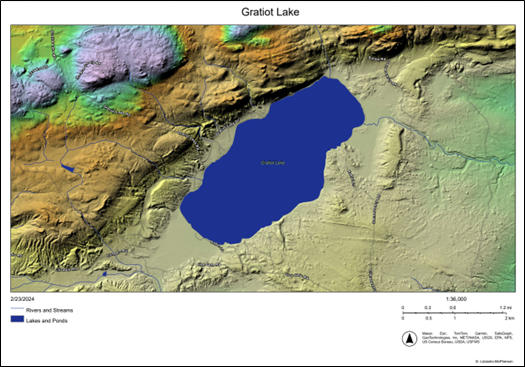
Type in a title for the file in the Title field. (e.g., Gratiot Lake)
Select the map size and orientation (i.e., landscape or portrait) from the Page setup dropdown menu.
Select the type of file from the File format dropdown menu.
Expand the Advanced options menu to set the scale of the map, include an Author, include a Copyright, set the DPI resolution, and check boxes to include the legend and north arrow.
Click the blue Export button at the bottom of the window. The export will appear as a downloadable link in the Exported file section. See example Layout Export below.
Export the Map Only
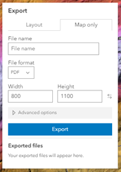
Type in the name for the file in the File name field.
Select the type of file from the File format dropdown menu.
Select the Width and Height of the file.
Expand the Advanced options menu to o Set the scale of the map and the DPI resolution, if desired.
Click the blue Export button at the bottom of the window. The export will appear as a downloadable link in the Exported file section. See example Layout Export below.